 |
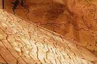
On the map, a giant irrigation system could be seen: in addition to the rivers, there are two 500-meter-wide channel systems, 12 dams, 300-500 metres wide, approximately 10 km long and 3 km deep each. The dams most likely allowed to pour water in the different networks. It has been calculated that their creation required digging off over 1 quadrillion cubic metres of earth. In comparison with that irrigation system, the Volga-Don Channel looks like a scratch today.
According to scientists, this map might represent a mysterious system of canals approximately 12,000 km long, with dams and powerful dikes. Close to these channels, they have noticed strange diamond-shaped areas whose destination is unknown.
|
It is interesting to note that the Torah, in the chapter of Garden of Eden (or Lost Paradise), speaks about a huge irrigation system « The Planting of the Garden: ...Now a river flowed out of Eden to water the garden; and from there it divided and became four rivers. The name of the first is Pishon. The name of the second river is the Gihon. The name of the third river is Tigris. And the fourth river is the Euphrates. The head of the Elohim(s) took the man and put him in the Garden of Eden to work it and take care of it. ». All of these rivers also represent a system of irrigation of several thousands kilometers.
|
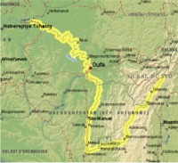 |
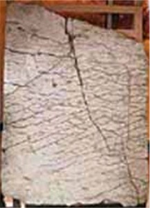
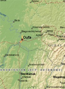
According to the map of Dashka Stone, the Belaya River (or White River) would have been artificial at the origin. This meandering River takes its source in the mountains of southwestern Urals, is 1.430 km long, and drains a basin of 142,000 km2. Its bed is established in deep gorges between the cities of Ufa and Sterlitamak.
At first, on account of vertical inscriptions visible on the map, the scientists supposed it could have been made by the ancient Chinese. As it is well known, vertical literature was used in Old Chinese language before the 3rd century. To check his supposition, professor Chuvyrov visited the Chinese empire library. Within the 40 minutes he was allowed to spend in the library he looked through several rare books, though none of them contained any literature similar to that on the slab.
After meeting with his colleagues from Hunan University, he completely gave up the « Chinese track ». The scientist concluded that the porcelain covering the slab had never been used in China. All the efforts to decipher the inscriptions were fruitless, but they seem to be constituted of hieroglyphic-syllabic symbols. Chuvyrov, however, states he has deciphered one sign on the map: it corresponds to the latitude of today's city of Ufa.
|
It was difficult to determine even an approximate age of the slab. At first, radiocarbonic analysis was carried out, afterwards defferent levels of stab were scanned with uranium chronometer, but the investigations showed different results and the age of the slab remained unclear.
While examining the stone, two shells were found on its surface. The age of one of them - Navicopsina munitus of Gyrodeidae family - is about 500 million years, while the second one - Ecculiomphalus princeps of Ecculiomphalinae subfamily - is about 120 million years old. That age was accepted as a « working version ».
A Group of Cartography from the University of Wisconsin, USA, studied the various elements of the Dashka Stone in a project on the History of Cartography and came to the conclusion that this three-dimensional map could be achieved only from aerial surveys, this type of work requiring the use of an extremely powerful computer for processing satellite data.
 |
Latest investigations of the map bring one sensation after another. Now, the scientists are sure it is only a fragment of a big map of the Earth. According to some hypothesis, there were a total of 348 fragments like that one. The other fragments could probably be somewhere nearby. In the outskirts of Chandar, the scientists took over 400 samples of soil and found out that the whole map was most likely situated in the gorge of Sokolinaya Mountain (Falcon Mountain) and could have been torn to pieces during the glacial epoch.
So, the Russian scientists are convinced that this 3-D map of the Ural region is in reality a small fragment of a huge cartographic model of 340 m x 340 m representing the Earth. Pr Chuvyrov is obviously very circumspect as to the authors of this map: « I don't like to talk about UFOs or extraterrestrials. So let us simply call the author of this map the Creator ».
Strangely, the Popol-Vuh gives some additional information allowing a better understanding of the possible use of this three-dimensional map and of its authors.
|
Planning a large project begins with the realization of a scale model on which we can think and work. Popol-Vuh says: « the Creator, the Maker, Tepeu, Gucumatz, the Forefathers, were by nature great sages and great thinkers. Then while they meditated, it became clear to them that when dawn would break, man must appear. Then they planned the Creation... ».
It seems that the authors of this map only used aerial ways because there are no traces of roads on the Dashka Stone. Strangely, the Popol Vuh confirms : « from where they were, they saw all, they saw the round face of the Earth ». The authors of this map, the Group of Creators, therefore appeared to be in the space during the planning of Creation.
|